Star Trek: Stellar Cartography – Larry Nemecek
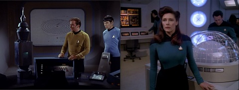
 The very first appearance of a facility serving some of the functions of stellar cartography was in September 1967’s classic episode The Changeling, where the Nomad probe was taken to the Enterprise’s auxiliary control room to view star maps to identify its point of origin, confirmed unexpectedly as a planet with one large natural satellite, third from a sun named Sol, the same origin as the starship itself. Over a quarter of a century would pass before the stellar cartography lab of the USS Enterprise NCC-1701-D was first seen in the sixth season episode Lessons.
 Filmed in the same year that Paramount launched Deep Space Nine, with two Star Trek shows in simultaneous production there was an inevitable split in both creative and financial resources, and possibly it was that loss of focus which allowed a derivative Mary Sue script (a sub-genre of fan fiction where a dazzling young officer arrives on the ship and the captain, usually James Kirk, falls helplessly in love with them) which would have been intercepted under other circumstances to be produced as an episode.
The saving grace in the episode is the performance of Patrick Stewart, but even he could not improve the modest environment the team could afford to create for stellar cartography, a standard set furnished with little more than a plastic dome and some fairy lights which ostensibly allowed Lieutenant Commander Nella Daren to take precise gravimetric readings to construct a mathematical model of an emerging star system which would not be fully formed for another two million years.
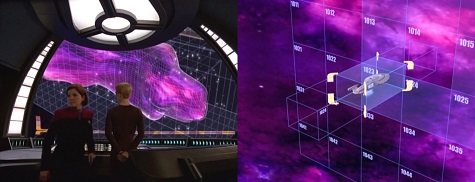
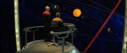 The full realisation of the stellar cartography lab would not take place until the release of the first feature film starring the Captain Picard and his crew, 1994’s Star Trek Generations, where it was rendered as a three storey circular set dominated by wraparound videoscreens, a massive expense for a single scene which could be justified as it elucidated a key plot point without which the audience would not be able to follow the film, that the path of the Nexus through space was being altered by Doctor Tolian Soran through local distortions in gravity.
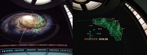
Under the name of astrometrics, a similar lab featured frequently in the later seasons of Star Trek Voyager, a narrative tool used to illustrate the Hirogen transmission arrays along which the Doctor’s holographic datastream was relayed to reach the USS Prometheus in the Alpha Quadrant (Message in a Bottle), the extent of the nebula through which Seven of Nine must pilot Voyager unaided (One), and to plan a heist on a Borg vessel to obtain transwarp coils (Dark Frontier) among many other instances.
 A scene focusing more on Picard’s reflections on his Reman clone, Praetor Shinzon, took place in the astrometrics facility of the Sovereign class NCC-1701-E in 2002’s Star Trek Nemesis, though it also served the dual purpose of establishing the vulnerable position of the Enterprise, far from the rest of the fleet who awaited their arrival beyond the Bassen Rift. As indicated by the name and in recognition of the less crucial role the scene plays in the logistics of the plot, it was again a modest facility, closer to that of the USS Voyager‘s rather than the elaborate refitted chamber of the Galaxy class NCC-1701-D.
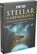
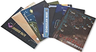
In each of these stories, stellar cartography was used to facilitate the storytelling, presenting a complex idea in a simple yet visually appealing way which would provide a foundation to understanding which could be easily grasped by the audience, a stepping stone to more challenging ideas, and the recently released Starfleet Reference Library: Stellar Cartography claims to build on this idea with, in the words of the publicity, “ten original, never-before-seen large-format maps of the Star Trek universe,” along with “a fully-illustrated reference book providing detailed information on planets, systems, and topography.”
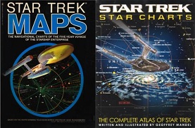
 The boxed set is principally credited to Larry Nemecek, the author of the Star Trek The Next Generation Companion who also served as managing editor for Communicator, the magazine of the Official Star Trek Fan Club and as a writer and researcher on the Star Trek Fact Files. In the more distant past, Nemecek was an uncredited technical contributor on Bantam’s Star Trek Maps (1980), a package of two large double sided maps accompanied by a booklet entitled Introduction to Navigation covering such topics as coordinate geometry, position determination, course calculations and deep space operations and procedures
A natural successor and companion to Franz Joseph’s legendary and often reprinted 1975 work Star Fleet Technical Manual, Star Trek Maps is now hard to come by, but in 2002 it was supplanted by Geoffrey Mandel‘s Star Trek Star Charts, an updated work which listed Nemecek as a contributor.
 A designer and artist on Insurrection, Deep Space Nine and Voyager, Mandel also had an association with Star Trek going much further back than his official roles with credits as associate editor on Ballantine’s Star Fleet Medical Reference Manual (1977) and writer and illustrator, along with Doug Drexler, on the USS Enterprise Officer’s Manual (1980) from Interstellar Associates. Also credited with astronomical art on Star Trek Maps itself, his book Star Charts was the evolution of that work reflecting the vast changes within the Star Trek universe through the films and the subsquent series.
With Stellar Cartography, the intention has apparently been to create a synthesis of these two previous products, but despite the increase from two double sided charts to ten single sided, the additional space is largely wasted, with the charts echoing information in increasingly deep but pointless detail; the Andorian sourced Known Space of 2386 is vast swathes of barely labelled colour, while the Federation Master Database presentations of the Alpha and Beta Quadrants as at 2386 provide a more detailed look at the same area and would be even more useful if they aligned correctly.
 Within the Alpha and Beta Quadrants, further amplification is offered of the Cardassian Union of 2364, the Imperial Klingon Empire at 2266 and the Romulan Star Empire at 2366; all three are drawn directly from Mandel‘s Star Charts, expanded in size, translated into the native languages yet reduced in detail. Most directly influenced by the equivalent in Star Trek Maps, Federation Historical Highlights is more informative on one sheet than spread across several pages as it was when updated in Star Charts, but is still cluttered; two sheets for different eras, the 23rd and 24th centuries, would have been more helpful still.
When dealing with a subject as vast, complex and contradictory as the many incarnations of Star Trek, it will be impossible to appease all interpretations, and inevitably, like the recent 150 Years of Federation, the historical charts are Enterprise centric.
 We are shown see the course of the NCC-1701 when it was taken by the Kelvans outside the Milky Way on a course to the Andromeda Galaxy, the passage of V’Ger through Klingon space in 2271 is recorded as is the final mission of the refitted NCC-1701 to the Mutara sector in 2286, yet the SS Valiant (Where No Man Has Gone Before), USS Defiant (The Tholian Web) and USS Intrepid (The Immunity Syndrome), ships equally important to their captains and crews, are only marked where they are lost. Interestingly, the often ignored animated series is acknowledged with the inclusion of the billion year gone Slaver Empire.
Further charts offer the Romulan War of 2162 and the Dominion War of 2379, though neither are presented in a way that is informative or articulate, a flat and static dilution of two dynamic conflicts which defined the eras in which they took place, nor does the 4th century representation of the trinary 40 Eridani system serve any purpose; why is Vulcan singled out for this sole honour, when none of the other home systems of the key species are so represented?
 The sole problem with 1999’s otherwise ecxcellent New Worlds, New Civilisations, a collection of in-universe essays inspired by the various worlds of the Federation, was that while each of the eighteen pieces were illustrated by over a dozen different artists and were supposedly written by various correspondents including an extract from the personal logs of Captain Kathryn Janeway, all were written by one author, Michael Jan Friedman, with the result that the pieces spoke in a uniform voice rather than the individual personalities of the many worlds.
This approach is also found in Stellar Cartography, with star charts purporting to originate from Federation, Klingon, Romulan and Cardassian sources, yet with the sole exception of the Dominion War illustration, all are depicted in the same style with no account taken of those varied and diverse cultures. All use an identical colour scheme (green for Romulan territory, red for Klingon, orange for Cardassian), with only the changing typeface differentiating the maps.
 Furthermore, all the charts are shown from the same perspective as if the numerous space faring races had come to a consensus as to which way the map should be held, a unanimous approval on the direction of galactic north, as it were, when each should have their own territory central. The suggestion that all the major powers have adopted the Federation sector system due to Earth being “considered the focal point of the immense sphere of Federation scientific influence” is an unconvincing argument which fails to distract from the limited imaginative scope of the creators.
The most egregious omission, however, could be summed up by Mr Spock’s appraisal of the battle tactics of Khan Noonian Singh, in that the designers of this package are guilty of “two dimensional thinking.” From the earliest season of Star Trek The Next Generation, the standard map of Federation space was shown to be a volume rather than a surface and as far back as Star Trek Maps the charts represented different planes through the same volume, yet Stellar Cartography makes no attempt has been made to represent the spaces in any three dimensional way. Resolutely two dimensional, it is a slice through an apple which gives no clue as to the true shape of the fruit, the Milky Way cleaved along the Galactic Plane but with no regard to what lies above or below.
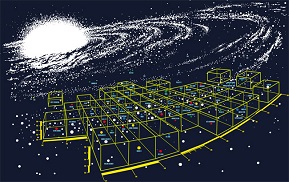 A result of this is that Federation space is shown as divided by both Romulan and Klingon space but nowhere is there an alternative perspective showing how the Federation loops below (or possibly above) the opposing empires. While the publicity boasts that the documents “showcase the Star Trek universe like never before,” what this fails to qualify is that the representation will be misleading and less useful than previously released material.
The accompanying 48 page book, once endpapers, acknowledgements, table of contents and copies of the charts themselves are discounted contains a mere nineteen pages of text, discussing the charts in their broadest terms as they tip-toe through the history of the universe, recounting a series of first contacts, conflicts, alliances, discoveries and technological advances.
 While it is admirable to have so concisely summed up several hundred hours of television history, for example acknowledging the role of the Preservers and even linking to the alternative universe of J J Abram’s recent movies with a note about the destruction of the Romulan homeworld by a subspace supernova, the overall impression is of an introductory chapter to a much more expansive tome. The statement “fully illustrated” is also misleading, as there are no illustrations other than the reproductions of the charts.
While Stellar Cartography is not as poor a product as On Board the USS Enterprise, it is a disappointing one in that it fails to match the possibility of what could have been nor the expectation set by the premium price tag. With insufficient clarity to appeal to a casual fan and no well presented new material to satisfy a collector, coupled with a recommended retail price of £60 (US list price $79.99), it is a failure for which the purchaser is paying dearly, and in no way does it justify the captain not getting his cup of Earl Grey.
Star Trek: Stellar Cartography is currently available from 47 North


